South Coast 2024

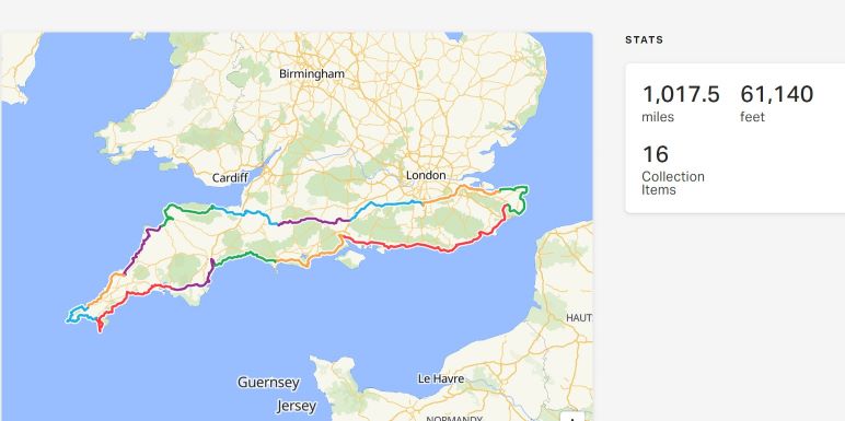
It’s now 10 years since I set off on my first long distance Cycle ride from Lands End to John O’Groats. I’ve completed one every year since, mostly about 1000 miles over a couple of weeks but as far as 2034 miles in 2016. This year I’m pre-occupied in getting the house I’m building finished so I’ve left it rather late in the year to set off. I’m hoping to cycle just over 1000 miles around the south of England, leaving home in South Somerset on 29th September for Minehead on the North Somerst coast and then making my way around the South West peninsula, along the south coast to the North Foreland of Kent and then back home keeping south of London. All being well I should be home on 13th October.

I haven’t endeavoured to raise any money for charity for a number of years but this year with the sad death of my dear friend Gareth Davies I’d like to persuade you to donate to the Bedford Blues Foundation which uses the power of sport and rugby to change lives in Bedfordshire. https://bit.ly/DonationsGD Maybe you didn’t know him but he was an inspiration to several generations of schoolchildren and rugby players and any money donated will be well spent and give me a boost. A penny a mile will give £10 but I hope you can be more generous. It would be nice if my efforts put at least £1000 in the kitty.

Day 1. Moors, levels and rough tracks

The weather was forecast fair and indeed it was, although much colder than of late and I was well wrapped up in bib tights and knitlock jersey when I left at about 11am, seen off by Annie and Jim.A person riding a bike on a paved path

AI-generated content may be incorrect.

I was feeling good, no real niggles and the bike was performing properly with no skipping gears.  The Boardman 8.9 E is now about 5 years old.  I’ve had it for four and the previous owner bought it new from Halfords.  As I do about 6000 miles a​​ year on various different bikes, I guess I’ve done about 20000 miles on it, as it is my main bike.  Like Trigger’s broom it’s had pretty much everything replaced at least once and before I left I put on a new chain ring, cassette and chain and, after a lot of fettling, it now changes gear on command and so far hasn’t missed a beat: probably the kiss of death.

I had a short climb up a steep pitch and used the motor but after that I cycled all the way to the foot of the Quantocks, about 40 miles in, before I fired it up again. I took a route much travelled, across to Podimore, now the end of the latest upgrade of the A303, not yet finished but it won’t be long before traffic is able to zip along and then through Long Sutton to Langport.  About 5 miles into the ride, I realised that I had left my waterproof overshoes at home and debated whether or not to ring Jim and ask him to meet me en route but decided I could probably buy some on the way.  There was no need of them today but the next couple of days promise rain and my cycle shoes are like colanders: cycling with an inch of water sloshing about inside your shoes is no fun so I definitely need something to keep my feet dry.  There is a shop in Langport that hires out bikes to cycle the Parrett Way but no overshoes available.  Not to worry, I was going through Bridgwater and found​​ 

A bicycle parked outside of a building

AI-generated content may be incorrect.

A good choice of Endura and I chose a pair with a ticket price of £43, which didn’t seem unreasonable, so imagine my delight when I was given a 15% discount:​​ sorted for under £37.  This had taken me a bit off route, but Rita managed to get me back on the canal path, that I should have travelled, without difficulty.  I was told to turn left off the canal path and found myself in the middle of a street fair, all sorts of fast food and a giant funfair.  It was slow work pushing the bike through the crowds, but I finally reached the end of the stalls, stopped to ask an official what it was all about, to be told that it was Bridgwater Fair, an annual event from Wednesday to Saturday, that has been running for 300 years.

A group of people standing in a line

AI-generated content may be incorrect.

I was now on a very quiet country lane, heading for Spaxton and then the Stoweys where I hit the Quantock Hills.  I’ve climbed it from the other side, trying vainly to beat Crowcombe Hill, every time having to GOAP, but never with a motor to help me.  It’s not quite so steep from Over Stowey and with the motor it was pretty easy.  I managed the two mile climb and was then faced with a choice: either go down Crowcombe and join the A358 which would have taken me all the way to Minehead, on a narrowish road with a lot of traffic, or embark on a cross country track of unknown surface which would take me to West Quantoxhead, Watchet and Blue Anchor.  I should have chosen the former but presumptuously decided I could manage what lay before me: ouch, the stone track was rough, shaking the poor bike and I was lucky not to come off on a couple of occasions.  Two and a half miles of it, up and down.  Great on a mountain bike with no extra weight but with two heavy​​ panniers it was no fun.  The upside was beautiful views of the Bristol Channel, on a day when I could see across to South Wales

A field with sheep in it

AI-generated content may be incorrect.

At one point I looked down on the Nuclear Power plant being built at Hinckley.

A view of a large body of water

AI-generated content may be incorrect.

And shared the road with some equine friends

A horse grazing on grass

AI-generated content may be incorrect.

After wondering if the bike would take much more I was back on asphalt at West Quantoxhead and made my way swiftly downhill to Watchet, which, I suppose, is really the start of my coastal journey

A marina with many boats

AI-generated content may be incorrect.

The road to Blue Anchor was closed to cars because of a landslip but I was able to climb out of Watchet and over the hill to join the coast road through Blue Anchor at the end of which my map showed a coastal trail to Minehead. Down some steps and along the shingle possibly, but I could not see a proper track so had to make my way up a sharp hill to join the A358 an hour or more later than I would have done had I gone through Crowcombe.  From here there were cycle tracks, past Dunster Castle, all the way into the centre of Minehead and I easily found the Duke of Wellington Hotel where I had a room booked.  I was able to leave the bike in the beer cellar and struggle my way up 2 flights of stairs with panniers and bike battery.  Still, I made it.

A map with a route

AI-generated content may be incorrect.


Day 2 Exmoor escapades


I think Wetherspoons generally provide good value for money so, when I was looking for somewhere to stay in Minehead, the Duke of Wellington was an obvious choice.  A bed for the night at £86 is rather more than I’m used to paying on these trips, breakfast adds another £8 or so, but when I looked round there was nothing cheaper – Minehead is expensive.  So, the Duke it was

A building with a sign on it

AI-generated content may be incorrect.

I ate in the restaurant, perfectly acceptable steak and kidney pudding with chips and peas and apple crumble and a pint of Ruddles cost £18.60 and an extra pint of Ruddles was an astonishing £1.79.  Apart from the beer, it wasn’t as cheap as I would expect from Spoons but they’ve got to make a living.

The weather forecast for today was pretty awful, especially later in the day so I decided on an early start.  I wasn’t especially hungry so skipped breakfast and was on my bike by 7.30.  I was headed for Porlock, one of the iconic climbs in British cycling.  The A39 out of Porlock ramps up to 1 in 4 but I decided to take the toll road from West Porlock which, although steep doesn’t hit quite those extremes. I passed a couple leading a young horse along the road. The horse took grave exception to my panniers and threatened to cart the owner; but I talked to him, and he seemed to settle down and allow me to pass.  I thought that I knew what I was doing but when I reached the toll house there was a sign on the gate saying “no bicycles”, use the adjoining footpaths.  I set off in hope of finding a way and had to push the bike up a steep path, at one point encountering a fallen tree.

A bicycle leaning against a fallen tree

AI-generated content may be incorrect.

I unclipped the panniers and lifted everything across and kept going only to find steep steps in my way.  At least once past them there seemed to be a ride that would take me back to the road and after having to unload once again, I joined the toll road just above the house and cycled the two or so miles of substantial gradient to the top, where I was surrounded by pheasants taking off in all directions for the next couple of miles. Apparently the Lilycombe shoot.

Having got up on top of Exmoor I was now trying to stay as close to the coast as possible.  The A39 was fairly benign and I got a bit of rest from climbing until I reached Countisbury with a steep descent into Lynmouth

A road with cars on it

AI-generated content may be incorrect.

Now I knew that Lynmouth Hill that leads up to the town of Lynton on the top of the hill, although quite short, has gradients steeper than Porlock, but there is no alternative for a bike, although foot passengers can use the cliff railway, a nifty device that works on gravity, pumping water from one car to the other to provide motive force

A building with a train going up a hill

AI-generated content may be incorrect.

so I gritted my teeth and, with maximum assist from the motor, made it surprisingly easily.  However this was only about 18 miles into a 60 mile journey so I was fairly fresh.

From Lynton the coast road goes up and down, once again taking to a toll road (this one accessible) and providing stunning views of the craggy coast

A view of a body of water from a hill

AI-generated content may be incorrect.

On past Lynton I encountered some very steep climbs and the amount of motor I was using was taking its toll on the battery, to the extent that I was seriously worried as to whether or not it would last the day.  On to Combe Martin

A rocky beach with a hill and trees

AI-generated content may be incorrect.

to which I descended with a horrible screech of brakes, frightening a dog walker on the way.  Another climb out towards Ilfracombe, past Watermouth Bay and the golf course until I found myself on an old railway line with an excellent tarmac surface which allowed me to get to the top of the last major climb without using the motor.

A sign with a map and text

AI-generated content may be incorrect.

Even so I was now down to about 15% capacity, knowing that I still had about 16 miles to travel, mainly along the Taw and Torridge Estuaries from Braunton to Bideford with strong winds and rain in the air.

A body of water with a rocky shore

AI-generated content may be incorrect.

I stopped in Braunton and bought a Mars Bar and some flavoured fizzy water which raised the energy levels, but I was cycling into a head wind, and it was hard work.  At Barnstaple I crossed the river and made my way back up the other side of the Estuary, now with the wind at my back but with incessant rain. At Appledore, now no longer the centre of shipbuilding that it was in past times, I joined the Torridge Estuary, necessitating a change of direction that, once again, brought the strong wind across me.  Finally after 61 miles I crossed the 14th​​ century Long Bridge into Bideford, only to be faced with a substantial climb.  Given the battery now showing 10% at most, I GOAPed until I reached a relatively flat area. For some unknown reason I hadn’t picked up that Ridewith GPS was taking me around the houses, including along some woodland tracks,  before arriving at the Clovelly Road, home of the Premier Inn where I am staying tonight.  Very annoying at the end of a long hard day but I finally arrived at about 5 pm.  Hopefully I’ll get a decent night’s sleep before another gruelling day heading for Wadebridge tomorrow.

A map with a route

AI-generated content may be incorrect.


Day 3 - Blowing in the wind

With Premier Inns you get what it says on the tin, a comfortable bed and good, if not exciting, food.  When I set out to plan this trip, I realised that I could probably stay in a Premier Inn on most nights, so I got in touch and asked them if they’d do a deal.  I thought that they might offer me a fixed rate for dinner bed and breakfast in exchange for a bit of publicity about a 75 year old cycling 1000 miles for​​ charity, but no they weren’t interested.  Maybe I failed to speak to the right people but, as they weren’t playing, I looked elsewhere for the best deals.  In the end I shall stay in three Premier Inns, instead of eleven, the first of which was in Bideford.  I arrived about 5.15pm, wet through and dripping all over the floor.  The receptionist didn’t seem the least bit fazed, just wanted my details and a credit card, asked me when I wanted feeding and told me​​ where my room was.  She did ask me, perfectly sensibly, not to charge my bike unless I was in the room.  I dripped my way into the lift and went up to the second floor, to about the furthest point I could possibly be, through three doors on fierce closers that are very difficult to manage with a heavily laden bike.  I finally made it and did my washing and charging before coming down and making my way across, in the still pouring rain, to the Brewer’s Fayre, as with Premier Inns also owned by Whitbreads.  As a little aside, and I had the same thing in Wetherspoons yesterday, when you venture through the door of the restaurant you are immediately asked if you have any allergies.  I should have thought that if people know that they have allergies they will ask if their particular allergy is a problem with any items on the menu.  Then again I suppose that it’s a way of getting the restaurant off the hook if someone suffers.  I dined on a very tasty salt and pepper Calamari with a tomato mayo, followed by not very good lasagne and a good blackberry and apple crumble.  It’s not fine dining but it’s perfectly acceptable, particularly when you haven’t eaten for almost 24 hours.  I washed it down with a couple of pints of Guiness at £4.75 a pop. Satisfied I departed to the blog and turned the light out at about 10pm.

Surprisingly I didn’t sleep well.  I have a Premier Inn bed at home as they are so comfortable, so I assumed with such a hard day of cycling behind me I’d be out like a light until the alarm went off at 7.30.  Unfortunately not: I woke at about 3 am and having had a pee and a drink of water, couldn’t get back to sleep.  Still, I was rested when I got up to go to breakfast at 0800.  Now Premier Inns breakfasts are excellent: pretty much anything you want in the way of cereals and yoghurt, full cooked breakfast including black pudding (yum yum) and croissants, pancakes and muffins if you’re still hungry.  I filled my boots, not expecting to stop for lunch, and was on the road by about 0930.  The day was overcast but dry but there was a 20mph wind from the west which would make the first part of the journey difficult as I was heading straight into it, making my way towards Clovelly on the A39.  The route I had planned made several diversions from the main road to get onto quieter country lanes, but, as the A39 was very quiet I stayed on it all the way to Bude, cutting my journey by about 5 miles. I passed the quaintly named Fairy Cross with a couple of grand bus shelters on either side of the road

A small stone building with a pointed roof

AI-generated content may be incorrect.

and then on past the Milky Way adventure park, at the entrance to which was, rather appropriately, parked a Muller lorry (sorry I can’t work out how to put the umlaut over the letter u).  Apparently the Park has nothing to do with Milk and everything to do with fairground rides and more but outside the school holidays, not doing much business.

Just short of Clovelly, about 10 miles into the journey the A39, rather grandly named the Atlantic Way, turns south which meant the wind was just behind my beam, occasionally giving me a bit of assistance.  I crossed into Cornwall

A sign on the side of a road

AI-generated content may be incorrect.

and was soon in Bude, crossing the river Neet and the canal where a family of Canada Geese made their way noisily downstream.

A group of ducks swimming in a river

AI-generated content may be incorrect.

The wind was still blowing hard as I made my way past Widemouth Bay, at one point forcing me to GOAP when a sharp gust almost blew me into the verge.  The breakers were rolling in but I didn’t see any hardy souls out on surf boards.

A road with a body of water and clouds

AI-generated content may be incorrect.

Having survived the journey along the seafront I took to the hills, climbing steeply up above the bay.

A view of a beach and a cloudy sky

AI-generated content may be incorrect.

This was now to be typical of the reminder of the day, up and down like a yoyo on some very steep grades which required the motor.  First along the coast and down to Millook

A rocky beach with a cliff

AI-generated content may be incorrect.

where I stopped and talked with a man having his lunch.  He was walking the SW coastpath in easy stages and had been at it for a decade or more.  He was making his​​ way from Crackington, my next seaside stop, to Widemouth, warning me that the road out of Millook was very steep in places: not steep enough to stop me making it to the top with secondary motor assistance and I carried on for another 5 miles before descending steeply to Crackington Haven

A rocky beach with a large rock formation in the background

AI-generated content may be incorrect.

where I stopped for a pot of tea in the café, joining a surprising number of people and dogs, including an Alsatian who had lost the use of his hind legs and was running around in a very smart carriage which supported his back end.  I was interested because 60 or so years ago we had a dachshund called Salami who suffered the same problem which we solved by making her a carriage out of tin and Meccano, with which she chased rabbits for another 6 or 7 years

A dog lying on grass

AI-generated content may be incorrect.

.

The hill out of Crackington was not as bad as Millook but still needed a lot of motor.  Next stop was Boscastle, a village that suffered a horrendous flood on the 16th​​ August 2004, 52 years to the day since Lynmouth, which I visited yesterday had the same treatment.  Sadly 34 people died in Lynmouth but, miraculously, there was no loss of life in Boscastle.  This has received a lot of publicity as it was recorded in detail on film and was the subject of a Channel 4 documentary.  What is not so well known is that Crackington suffered similar flooding on the same day, again without fatalities.  Hard to believe the power of water on a gloomy autumn day.

A collage of houses destroyed by a flood

AI-generated content may be incorrect.

Onwards, and again upwards for the three miles to Tintagel.  I skirted the village and didn’t visit the medieval castle, often associated with the legends of King Arthur, the ruins of which stand on the cliff tops below the main village. A mile or so past Tintagel I climbed what must be the steepest hill I’ve yet encountered.  It wasn’t very long but it forced me to GOAP even though I had full power on the motor. I pushed for 100 yards or so along a very narrow lane, meeting  a VW beetle and having to push myself tight against the bank to let her pass.  Fortunately that was enough but it wouldn’t have been for the SW Water van that I met 50 yards further on when the road had widened.  I remounted and kept going, knowing that with about 10 miles to go the worst of the climbing was over.  The result of all the climbing was that the battery was getting very low, only about 15% remaining but it was sufficient to get me to my destination in Wadebridge where I am booked into the second Premier Inn of my journey.  I arrived at about 5pm, fortunately not as wet as yesterday.

A map with a route

AI-generated content may be incorrect.


Top of Form

Day 4 - Cornish ups and downs

I filled you in on Premier Inns last night: they’re all much the same but seem to have their own little quirks.  I pitched up at Wadebridge at about 5pm, this time dry and a little more energetic.  PI have their own in-house restaurants at many of their outlets, which they term Thyme, and there were two girls laying up for the evening when I arrived. I was booked in and told that it was company policy not to allow charging of electric bikes on site, a variation on “don’t do it when you’re not in the room” that I was told last night.  Needless to say, I made the right noises but proceeded to charge my battery whilst I was in the room.  Which policy is correct, I don’t know but I’m not going to ask the question of HO in case I get the wrong answer (from my POV).

I did the usual and came down for dinner at about 1830.  The menu at Thyme is pretty much the same as Brewer’s Fayre, maybe fewer choices but not by much.  As the Calamari the night before was so good I went for it again: this time a portion twice the size of yesterday but equally good and I followed up with a chicken Makhani curry with Naan and Poppadum, and very good it was too.  I drank Doom Bar x2 for which I had to pay extra and went for a pud which cost me an extra £2. I wanted cheesecake but there was none, so went for a chocolate sundae which was disappointing.  Putting it all together a filling dinner and breakfast cost me about £36 which is not too bad.

The morning dawned fair, still a bit of wind about and a chill in the air but no forecast rain.  I’m dressing up in bib tights and a warm jersey and suspect that I shall do so for the whole trip.  Breakfast was PI best and I filled up with the expectation that I wouldn’t have lunch.  I was on the bike by about 0930 and made my way to the bridge over the River Camel. 

The Camel trail follows the track-bed of the North Cornwall and Bodmin to Wadebridge railways. Cornwall County Council acquired the land in 1980 and converted the bed to a public trail which now runs from Wenford Bridge north of Bodmin to Padstow.  I remember riding bikes along the trail, 35 years+ ago, en famille, including our Jack Russell terrier, Tipsy, who, daughter Kate reminds me, rode in a pack on my back and rested her paws on my shoulder whilst she enjoyed the wind in her face: it caused some merriment from other users.  As I posted a picture of Salami yesterday, here’s one of Tipsy (sadly, I can’t find the one of her on a wind-surfer) but she was a game little dog who’d try pretty much anything.

A dog sitting in the grass

AI-generated content may be incorrect.

Anyway I joined the trail from Wadebridge to Padstow and there were several others, including dogs, enjoying the dry weather, The Camel river opens out into its estuary at Padstow with Trebetherick and Rock, known as Chelsea-on-Sea, on the opposite bank.  Rock is also home to Sharp’s brewery, now owned by Molson Coors, who’s most famous brand is Doom Bar, named after the sand bar in the middle of the estuary that has caused countless shipwrecks.

A view of a beach and a blue sky

AI-generated content may be incorrect.


Towards the end of the trail you cross an iron bridge with a safety warning on it.  Why fire engines are considered expendable is beyond me.

A bridge over a hill

AI-generated content may be incorrect.

I made my way around the edge of Padstow, sometimes known as Padstein after its most famous resident Rick Stein who owns several food outlets in the town and headed down the coast, now with the wind mainly behind me.  I dropped down to Harlyn Bay, narrowly avoiding a double deck bus coming in the opposite direction

A sandy beach with trees and a cloudy sky

AI-generated content may be incorrect.

And climbed up a steepish hill which I managed without engine.  As yesterday this was the pattern for the day: regularly up and down 2 or 3 hundred feet, sometimes with and, less often, without the engine.

Next sea visit was Mawgan Porth about 5 miles down the coast.  As expected not many people out in the bracing wind

A sandy beach with a rocky hill and a body of water

AI-generated content may be incorrect.

Onwards to Watergate, passing Cornwall (Newquay) airport.

A beach with a cliff and a house

AI-generated content may be incorrect.

and Porth, now close to Newquay, the biggest settlement on the North Cornwall coast.  The working harbour has all but disappeared and tourism is the main earner.  It’s a rather depressing place on the first day of October, still a number of people wandering around the streets; but shops and businesses do little trade outside the summer season.  I cycled around the whole town,

A body of water with a hill and buildings in the distance

AI-generated content may be incorrect.

even venturing out on a rough track to the Headland and back along the Gannel that marks the southern boundary of the town, today bereft of water.

A group of boats on a beach

AI-generated content may be incorrect.

I passed Fistral beach, known world-wide for it’s surf, just as a brief storm came and went in a few minutes.  I sheltered in a bus stop to put on a rain jacket but it was soon unnecessary.

A beach with waves crashing on the shore

AI-generated content may be incorrect.

I then found myself dropping down a very steep and narrow road to the National Trust beach at Trevaunance.  The climb up again was the steepest of the day.

A view of a beach from a hill

AI-generated content may be incorrect.

Next stop Porthtowan.  I admit I didn’t get down to sea level on this occasion but took the picture from on high

A beach with houses and a cliff

AI-generated content may be incorrect.

I was now heading pretty much due south, keeping close to the coast but seeing no sign of the sea until I reached Perranporth